
5min 52s Novice Spanish
Overview of How does GPS enhance the ShakeAlert® EEW system?
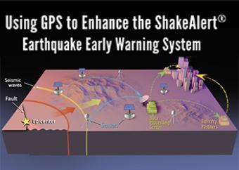
The ShakeAlert Earthquake Early Warning system uses over two thousand seismometers and GPS sensors to detect earthquakes rapidly and alert people in the affected areas. The ShakeAlert System does not predict earthquakes. Instead, within seconds after an earthquake starts, the ShakeAlert system quickly estimates an earthquake's location, magnitude, and where dangerous shaking might occur.
CLOSED CAPTIONING: A .srt file is included with the download. Use the appropriate media player to utilize captioning.
ANIMATED GIFS (MP4 FORMAT): short extracts of this animation are available (below right) as Optional files.
Youtube version: Click on "Watch Embedded Video"
Related animations:
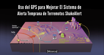
El sistema de alerta temprana de terremotos ShakeAlert utiliza más de dos mil sismómetros y sensores GPS para detectar terremotos rápidamente y alertar a las personas en las zonas afectadas. El sistema ShakeAlert no predice los terremotos. En cambio, segundos después de que comienza un terremoto, el sistema ShakeAlert estima rápidamente la ubicación, la magnitud y el lugar donde podrían ocurrir temblores peligrosos.
We encourage the reuse and dissemination of the material on this site as long as attribution is retained. To this end the material on this site, unless otherwise noted, is offered under Creative Commons Attribution (CC BY 4.0) license
