
Date: June 10, 2024 Novice
Welcome to "What’s Inside the Earth?" an interactive digital poster designed to engage students from middle school through introductory undergraduate, and the general public. This novice-level resource introduces learners to the vital role seismic waves play in uncovering the composition and structure of Earth's interior.
Hovering over the poster’s text and question marks gives you magnified views and the questions that are answered by clicking the question marks:
Embedded within the poster are links to Earthscope’s engaging videos and TikToks as well as links to several of Earthscope’s apps which answer the above questions. Within the apps, students are provided with real seismic data and records of specific earthquakes that have occurred world-wide. Students can explore seismic events, analyze data, and draw connections between theoretical knowledge and real-world applications.
Students work first in small groups, and then as a whole class to compare predicted seismic wave travel times, generated by students from a scaled Earth model, to observed seismic data from a recent earthquakes. This activity uses models, real data and emphasizes the process of science.
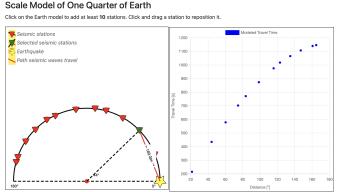
New Version! Major Update! In this learning app, students compare observed seismic data to predictions they make from a model, to determine that the Earth must have a layered internal structure and to estimate the size of Earth's core.
Seismic Waves is a browser-based tool to visualize the propagation of seismic waves from historic earthquakes through Earth’s interior and around its surface. Easy-to-use controls speed-up, slow-down, or reverse the wave propagation. By carefully examining these seismic wave fronts and their propagation, the Seismic Waves tool illustrates how earthquakes can provide evidence that allows us to infer Earth’s interior structure.
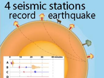
A cow and a tree in this narrated cartoon for fun and to emphasize that seismic waves traveling away from an earthquake occur everywhere, not just at seismic stations A, B, C, and D. A person would feel a large earthquake only at station A near the epicenter. Stations B, C, D, and the cow are too far from the earthquake to feel the seismic waves though sensitive equipment records their arrival.
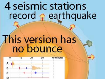
This companion to the animation "Four-Station Seismograph network" shows the arrival of seismic waves through select wave paths through the Earth (P and S waves) and over the surface of the Earth. The movement at distant stations occurs at a microscopic scale. While that doesn't result in noticeable movements of the buildings, the arrivals are recorded on sensitive seismometers.
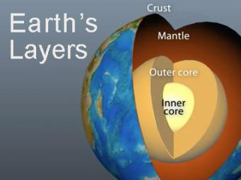
The Earth has 3 main layers based on chemical composition: crust, mantle, and core. Other layers are defined by physical characteristics due to pressure and temperature changes. This animation tells how the layers were discovered, what the layers are, and a bit about how the crust differs from the tectonic (lithospheric) plates, a distinction confused by many.
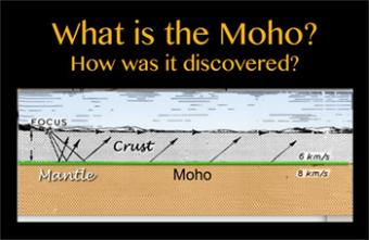
Without understanding what it is, we often hear the phrase “down to the Moho”, meaning very very deep. The Mohorovicic Discontinuity, commonly called the “Moho” is recognized as the boundary zone between Earth's crust and the mantle. Spoiler Alert: It is about Snell’s Law.
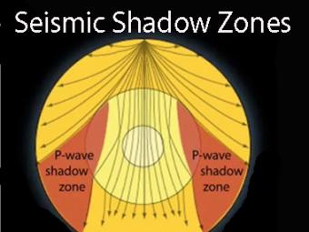
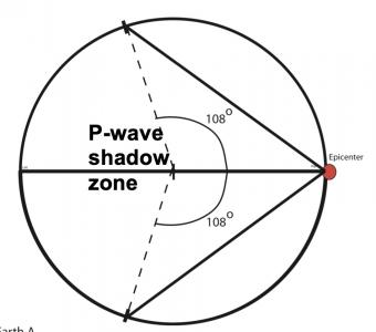
Seismic shadow zones have taught us much about the inside of the earth. This shows how P waves travel through solids and liquids, but S waves are stopped by the liquid outer core.
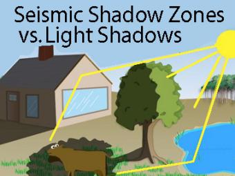
The wave properties of light are used as an analogy to help us understand seismic-wave behavior.
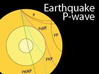
The shadow zone is the area of the earth from angular distances of 104 to 140 degrees from a given earthquake that does not receive any direct P waves. The different phases show how the initial P wave changes when encountering boundaries in the Earth.
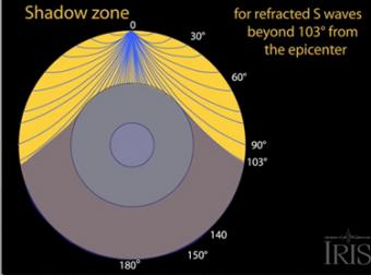
The shadow zone results from S waves being stopped entirely by the liquid core. Three different S-wave phases show how the initial S wave is stopped (damped), or how it changes when encountering boundaries in the Earth.
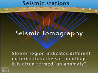
Seismic tomography is an imaging technique that uses seismic waves generated by earthquakes and explosions to create computer-generated, three-dimensional images of Earth's interior. CAT scans are often used as an analogy. Here we simplify things and make an Earth of uniform density with a slow zone that we image as a magma chamber.
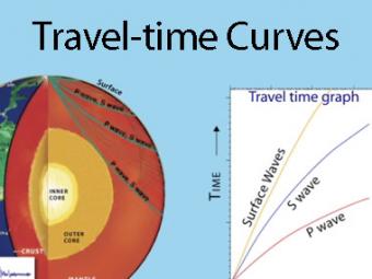
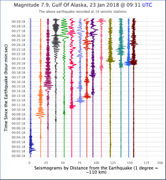
A travel time curve is a graph of the time that it takes for seismic waves to travel from the epicenter of an earthquake to the hundreds of seismograph stations around the world. The arrival times of P, S, and surface waves are shown to be predictable. This animates an IRIS poster linked with the animation.

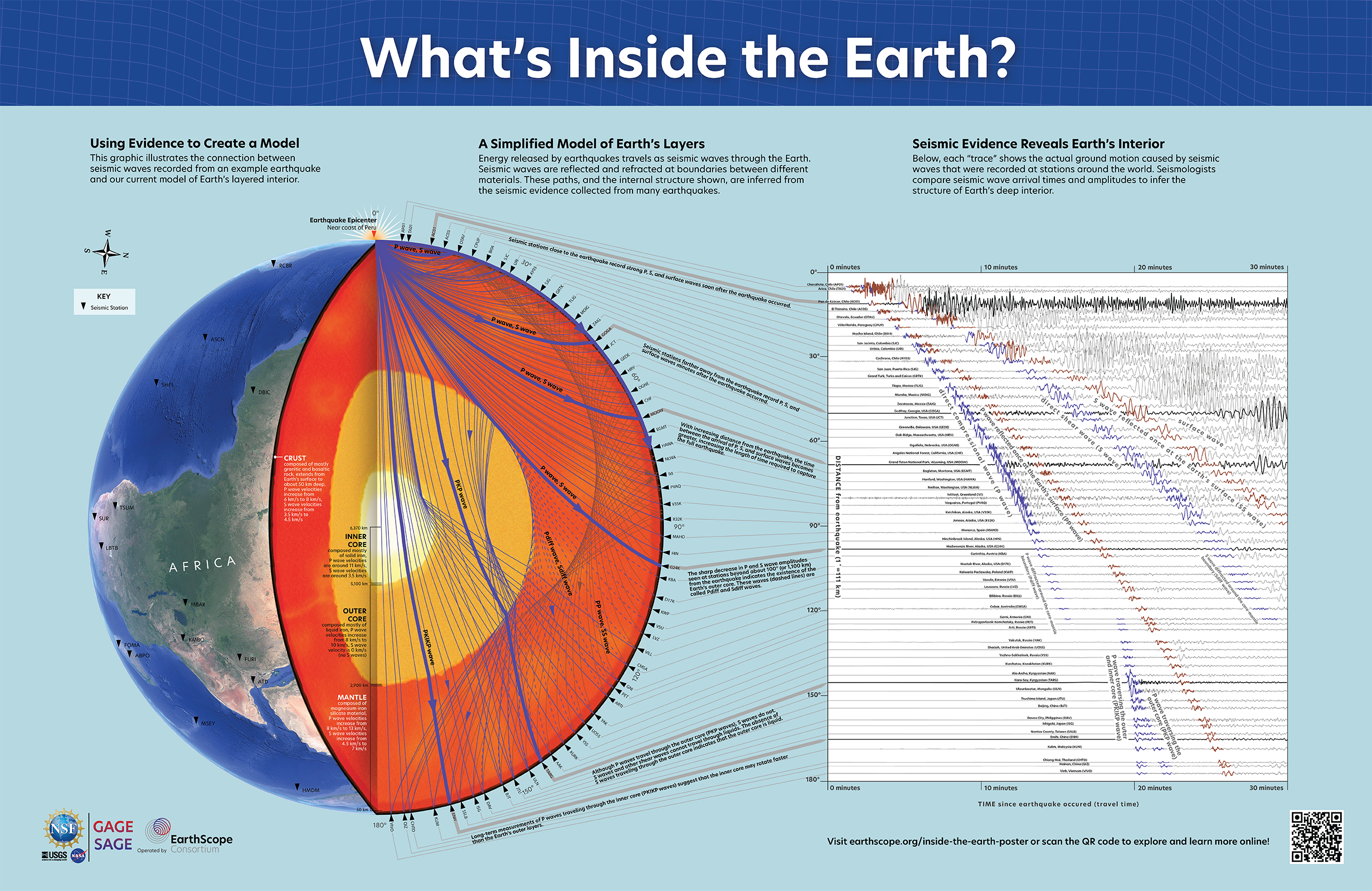
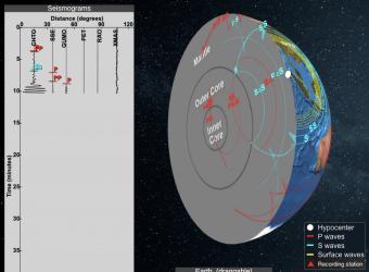
Seismic waves from earthquakes ricochet throughout Earth's interior and are recorded at geophysical observatories around the world. The paths of some of those seismic waves and the ground motion that they caused are used by seismologists to illuminate Earth's deep interior.
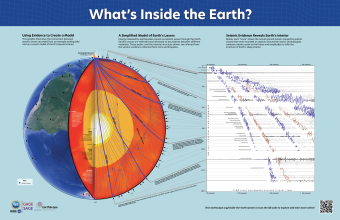
Seismic waves from earthquakes ricochet throughout Earth's interior and are recorded at geophysical observatories around the world. The paths of some of those seismic waves and the ground motion that they caused are used by seismologists to illuminate Earth's deep interior.
_thumbnail.png)
Las ondas sísmicas provenientes de los terremotos rebotan en todo el interior de la Tierra y son registradas en los observatorios geofísicos de todo el mundo. Las trayectorias de algunas de esas ondas sísmicas y el movimiento de tierra que causan son utilizadas por los sismólogos para iluminar las profundidades de la Tierra.
We encourage the reuse and dissemination of the material on this site as long as attribution is retained. To this end the material on this site, unless otherwise noted, is offered under Creative Commons Attribution (CC BY 4.0) license
